The official logo.

A stamp released by the USA during the IGY.
With dramatic stories of exploration challenged by snow storms, mechanical breakdowns, crevasses opening up into chasms, ferocious katabatic winds, and tensions between the teams, it’s easy to overlook that an important parallel project of scientific research was also being undertaken.
The International Geophysical Year (IGY) was a collaborative project involving 67 countries. There were more than 4000 research stations involved around the world. The focus was on geophysical observations and, at that time, it was the largest and most important international scientific effort ever undertaken.
The IGY was a significant project in the history of science, laying the foundation for a great deal of further research.
Special attention was given to the Antarctic. The New Zealand Government had been invited to establish a station on Ross Island as part of the international network of stations. Dr Trevor Hatherton was appointed leader of the New Zealand scientific team. Between 1957 and 1958, the New Zealanders carried out research into 11 fields of science.
Through seismic and geodetic surveying carried out during the Commonwealth Trans-Antarctic Crossing, it was revealed that Antarctica was one continent – a great basin with central highlands.
Glaciology research into ice depths produced radically new estimates of the earth’s total ice content. Improved meteorological forecasting came about through atmospheric studies. And the research produced a better understanding of seismological phenomena in the Southern Hemisphere.
The earth’s magnetic field extends from the core of the planet out into space. The team in Antarctica measured changes in this geomagnetic field through surveys both on land and at sea, and through the study of about 50 rock samples collected from the Wright Valley area.

IGY geophysicist taking magnetic observations.

Bob Miller of the Southern Survey Party taking a noon-sight on New Year’s Day.

View looking across penguin rookery to Hallett IGY Station with Mt Herschel in background.
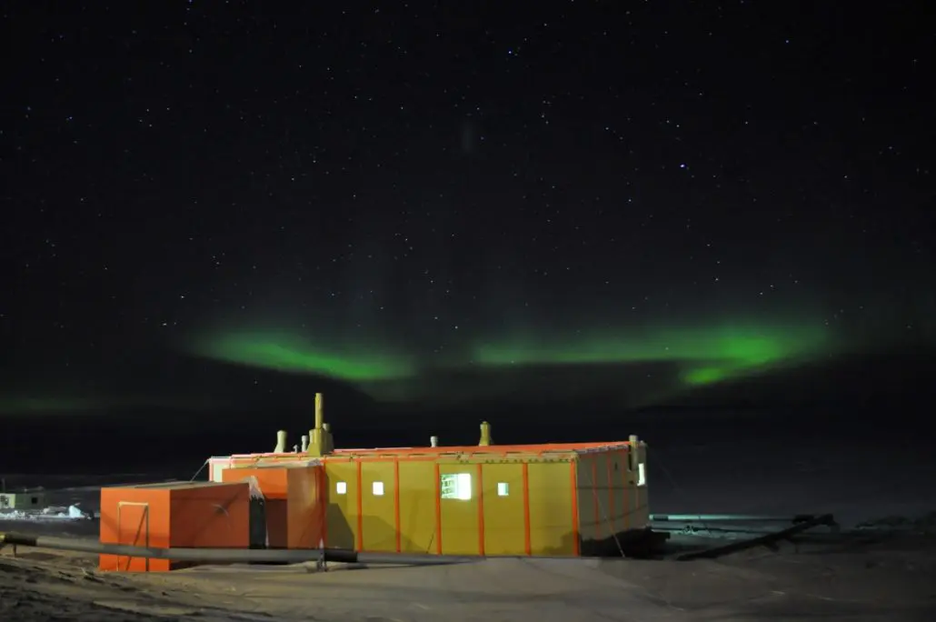
The busy scientific programme also looked at the behaviour of radio waves in the ionosphere, taking soundings at both Scott Base and Hallett Station (a joint New Zealand and American station), as well as making observations of the aurora australis (‘Southern Lights’), and other night sky phenomena, recorded on camera and through spectrography. The timing of the IGY was chosen to coincide with a period of maximum solar activity and several eclipses, making the research on the Sun especially significant.
Land-based biology was another important field of study. Lichens were collected from many areas; as were micro-organisms from soil and debris, and those taken from blood samples from vertebrates living in Antarctica. The populations of seals, penguins, skua also came under close observation.
Studies in oceanography, geology, and cartography were also part of the schedule.
The IGY clearly demonstrated the value of Antarctic research, and Scott Base has supported New Zealand’s scientific programmes in Antarctica ever since.
To learn about New Zealand’s scientific programmes in Antarctica today, visit Antarctica New Zealand.
Aurora and other night sky phenomena
A natural electrical phenomenon characterised by the appearance of streamers of reddish or greenish light in the sky, especially near the northern or southern magnetic pole. The effect is caused by the interaction of charged particles from the sun with atoms in the upper atmosphere. In northern and southern regions it is respectively called aurora borealis or Northern Lights and aurora australis or Southern Lights.
Visit Aurora Service for latest news, aurora forecasts and southern lights information.
![]()
 Martin Meldrum
 Cartography
The science or practice of drawing maps.
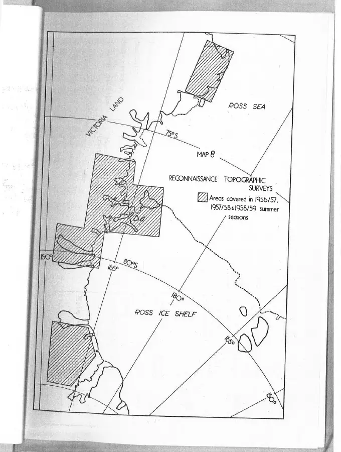
Map from the Antarctic Research Activities Report (1957-1958) – Map 8 shows the areas covered during reconnaissance topographic surveys in the Ross Sea Region, this work was carried out chiefly by dog teams with air support and by man-hauling parties.
 Antarctic Heritage Trust
 Climate and weather
The study of weather conditions prevailing in an area in general or over a long period. Weather stations located at Scott Base and nearby Arrival Heights, are part of a long-term and continuous climate monitoring programme. The stations collect temperature, wind barometric pressure and solar radiation data.
These temperature records began with Sir Edmund Hilary in 1957 are still being collected and used by scientists, and operational staff at Scott Base. Each morning at 9.00 am, just as the 1957 IGY team did, Scott Base staff take manual readings of the temperature, wind, pressure, cloud cover and visibility. It is the longest running continuous temperature record in Antarctica and is used to verify data collected from modern electronic sensors.
![]()
Geology
The science which deals with the physical structure and substances of the earth, their history, and the processes which act on them.
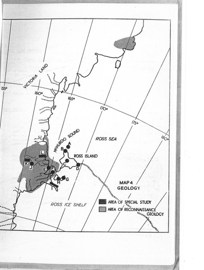
Map from the Antarctic Research Activities Report (1957-1958) – Map 4 shows areas in the Ross Sea Region where special geology studies were conducted.
 Antarctic Heritage Trust
 Geomagnetism
Earth’s magnetic field, also known as the geomagnetic field, is the magnetic field that extends from the Earth’s interior out into space, where it interacts with the solar wind, a stream of charged particles emanating from the Sun.
Maps from the Antarctic Research Activities Report (1957-1958) – Map 1 shows the location of terrestrial survey field stations and declination stations. Map 2 shows the traverse of seaborne surveys in the Ross Sea region.
 Antarctic Heritage Trust
Gravity
In physics this is the force of attraction between all masses in the universe; especially the attraction of the earth’s mass for bodies near its surface.
Gravity has been measured in Antarctica since 1957, which contributes to monitoring of global change by providing a benchmark for measuring movement of the earth. Since 2001 K150: Land Information New Zealand (LINZ) has maintained tide gauges at Scott Base and Cape Roberts to provide scientists with consistent, continuous and authoritative data for monitoring sea level in this part of the world. The combined measurements of gravity and sea level assist with monitoring global change, specifically sea level rise.
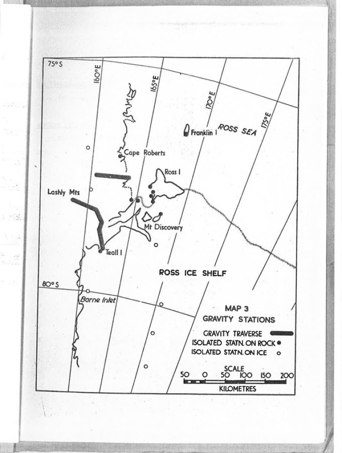
Map from the Antarctic Research Activities Report (1957-1958) – Map 3 shows the locations of gravity stations established during the 1956/57, 1957/58 and 1958/59 summer seasons.
 Antarctic Heritage Trust
 ![]()
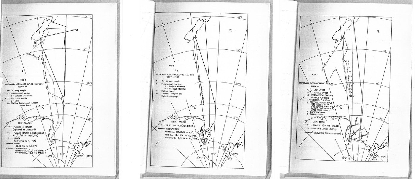
Oceanography
The interdisciplinary study of all aspects of the ocean. Oceanography covers a wide range of topics, from marine life and ecosystems, to currents and waves, to the movement of sediments, to seafloor geology.
Maps from the Antarctic Research Activities Report (1957-1958) – Map 5 shows the ship tracks and main oceanographic stations during the 1956/57 summer season. Map 6 shows the ship tracks and main oceanographic stations during the 1957/58 summer season and Map 7 shows the ship tracks and main oceanographic stations during the 1958/59 summer season.
 Antarctic Heritage Trust